The applied models in the project
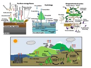 CLM, a key component of the Community Climate System Model (CCSM3), plays a crucial role in global climate studies. It covers various processes like biophysics, radiation interactions, heat transfer, hydrology, and vegetation characteristics. The version used in this study, CLM 3.5, introduces significant improvements in hydrological cycle simulation. Changes include updated surface datasets, enhanced canopy integration, scaled canopy interception, a simplified runoff model, a groundwater model, and a new frozen soil scheme. Modifications also address soil water availability, a resistance term for soil evaporation control, and nitrogen limitations on plant productivity. Notably, the CLM simulations in the reference dataset require no calibration; instead, they utilize a spin-up approach to achieve dynamic equilibrium by considering initial conditions and states.
 GeoFrame is a flexible computer-based hydrology system, offering a range of modeling solutions built on the Object Modeling system framework. With numerous components, it covers various aspects like rainfall-runoff, snow dynamics, evaporation, transpiration, infiltration, terrain analysis, interpolation, and calibration. GeoFrame supports diverse modeling paradigms, including process-based, lumped, and machine learning approaches. Notably, it accommodates spatially disjoint catchments, enabling modeling at different scales, from point to large catchments like the Blue Nile.
mHM is a gridded distributed hydrological model developed by the Helmholtz Centre for Environmental Research GmbH (UFZ). It encompasses various processes including canopy interception, snow dynamics (accumulation and melt), soil moisture dynamics, infiltration, surface runoff, evapotranspiration, deep percolation, subsurface storage, baseflow, discharge generation, discharge attenuation, and flood routing. The model’s source code is highly modular and written in Fortran. mHM has been extensively applied in over 1,000 European basins and globally in more than 5,000 GRDC basins, spanning a range of sizes and spatial resolutions from 1 km by 1 km to 100 km by 100 km.
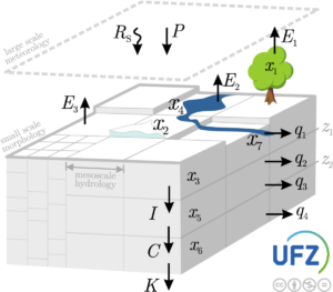
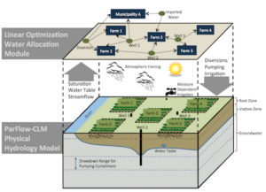 ParFlow-CLM is an advanced, massively parallel hydrologic model specifically tailored for supercomputing environments, serving as a benchmark for supercomputing centers. It simulates variably saturated groundwater flow and overland flow while integrating land-surface processes such as evaporation and transpiration through the Common Land Model (CLM). The model’s application spans from test sites to continental scales, operating on sub-daily to climate time scales, and is utilized for scientific research as well as quasi-operational purposes globally. Moreover, ParFlow is a vital component of the Terrestrial Systems Modeling Platform (TSMP), which comprehensively addresses the terrestrial water and energy cycle from bedrock to the atmosphere.
 PCR-GLOBWB is a global hydrology and water resources model based on a grid system, developed at the Department of Physical Geography, Faculty of Geosciences, Utrecht University, the Netherlands. This model comprehensively represents the terrestrial component of the hydrological cycle. For each grid cell and daily time step, PCR-GLOBWB simulates moisture storage and water exchange between the soil, atmosphere, and underlying groundwater reservoir. The model fully integrates human water use, estimating demands for irrigation, livestock, industry, and households. These demands are then translated into actual withdrawals from groundwater and surface water sources, such as rivers, lakes, and reservoirs, considering water availability and maximum groundwater pumping capacity.
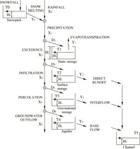
TETIS is an eco-hydrological model with spatial distribution, developed by the Instituto de Ingeniería del Agua y Medio Ambiente (IIAMA) of Universitat Politècnica de València (UPV) since 1995. This model is versatile, accommodating a wide range of spatial scales from under 1 km² to 60,000 km², various spatial resolutions, and diverse climatic conditions worldwide. TETIS considers spatial heterogeneity in inputs, parameters, and state variables, offering sub-modules for reservoir operation, snow accumulation and melting, sediment erosion, transport and deposition, nitrogen cycle, natural dynamic vegetation, flood and drip irrigation, and crop production. The model incorporates satellite data, such as NDVI and surface soil moisture, in a multi-objective calibration process.
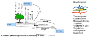
TSMPis a fully integrated terrestrial model that balances water and energy from groundwater through the land surface to the atmosphere. It incorporates Parflow for variably saturated groundwater and surface water flow, CLM for land surface processes, and COSMO, the former weather prediction system of the German Weather Service, for atmospheric processes.
 Wflow_sbm is a distributed hydrological model developed by Deltares, written in Julia. Initially based on the topog_sbm concept, it aims to balance between low-resolution, low-complexity (conceptual) and high-resolution, high-complexity (physics-based) hydrological models. Achieving this balance involves parameters grounded in physical characteristics or processes, maintaining relatively fast run times. The model encompasses various hydrological processes including glacier and snow dynamics, lakes and reservoirs (including operations), evapotranspiration, unsaturated zone dynamics, lateral subsurface flow, and multiple surface flow routing modules.