
Which step are we at (updated in May 2025)?
Management and Synthesis Activities (Status: In progress):

WP0 is in charge of the coordination of the project and the communication of between project partners and with ESA delegates.
Consolidation of a Reference EO dataset (Status: Done):
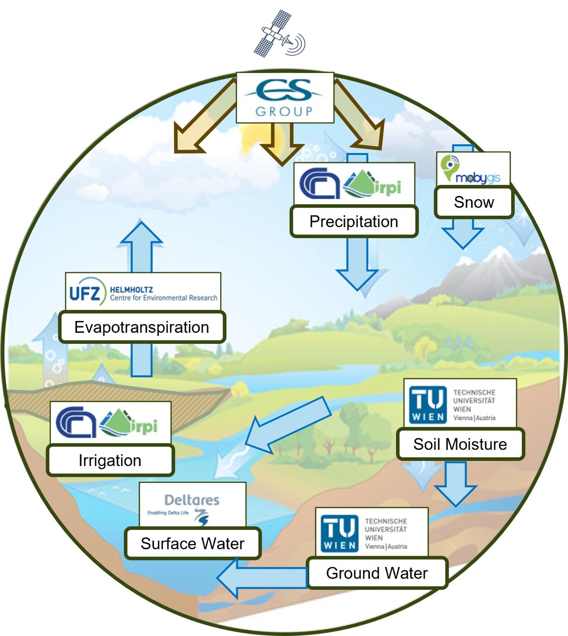
Water cycle variables studied during the project and the hosting partner ( sources of figure extraction)
The first step of the project is to catalogue, retrieve and prepare a set of reference Earth Observations (EO) dataset. This dataset gathers remotely-sensed products monitoring essential variables from the continental water cycle at high-resolution that are soil moisture, evapotranspiration, precipitation, snow, surface water, ground and total water storage, irrigation. This Work Package (WP) is a group effort as several partners from the consortium implemented on this dataset, each partner being leader of a given variable from the above list while CSGROUP managed the overall WP. The purpose was then to organize a collection of EO products and also extract and prepare them for each of the study regions and the study period. This EO reference dataset will then be studied and compared through the Round Robin study in WP4.
Consolidation of a Reference LSM dataset (Status: Done):
4dHydro working package 2 aims to deliver and benchmark a (tier 1) hydrological reference dataset. This dataset comprises of existing LSM/HM simulations from previous studies and covers a wide range of LSM/HM models and simulations. Despite this diversity, simulations in the reference dataset are uniformly formatted following our storage protocol (see the working package 2 User Manual under 4dhydro.eu/outputs). This uniformity allows for seamless comparisons across simulations in our benchmark. The benchmark comprehensively validates the dataset’s simulations using observations from discharge gauges, evapotranspiration towers, soil moisture stations, and satellite-based total water storage anomaly measurements.
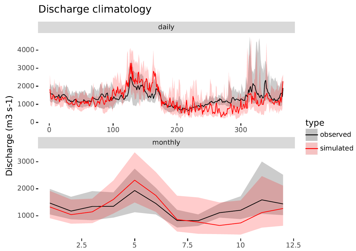
comparison of simulated and observed discharge
Community Open Science Data & Code sharing Tool (Status: In progress):

WP3 is developing an Open Science Data and Code sharing Tool offering easy access to the EO and non EO datasets, code and model results. This team is responsible for managing the Open Science Catalogue.
- Round Robin Experiment (Status: Done):
Revision date: March 14, 2024
WP4 has the goal of cross-comparing state-of-art, high resolution Earth Observation datasets in the domains of: soil moisture, precipitation, evapotranspiration, and snow depth and extent. The output of the activity feeds into the subsequent EO-model integration project phase by defining strengths and weaknesses of the observational products with respect to the most comprehensive available reference data. Advanced statistical methods are employed to provide uncertainty information and objective skill criteria for the candidate datasets, as well as defining their spatial scale representativeness (figure below).
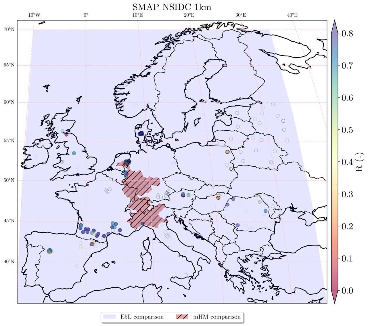
Overview of the multi-scale analysis of the SMAP NSIDC 1km soil moisture product (Lakshmi & Fang, 2023) over the various domains, against the 0.1° resolution ERA5 Land (E5L, Muñoz-Sabater et al., 2021), the 0.0125° mesoscale Hydrologic Model (mHM, Samaniego et al., 2010), and the ISMN point measurements (Dorigo et al., 2021). The coloured points show the temporal correlation against ISMN
- Dorigo, W., Himmelbauer, I., Aberer, D., Schremmer, L., Petrakovic, I., Zappa, L., Preimesberger, W., Xaver, A., Annor, F., Ardö, J., Baldocchi, D., Bitelli, M., Blöschl, G., Bogena, H., Brocca, L., Calvet, J.-C., Camarero, J. J., Capello, G., Choi, M., Cosh, M. C., van de Giesen, N., Hajdu, I., Ikonen, J., Jensen, K. H., Kanniah, K. D., de Kat, I., Kirchengast, G., Kumar Rai, P., Kyrouac, J., Larson, K., Liu, S., Loew, A., Moghaddam, M., Martínez Fernández, J., Mattar Bader, C., Morbidelli, R., Musial, J. P., Osenga, E., Palecki, M. A., Pellarin, T., Petropoulos, G. P., Pfeil, I., Powers, J., Robock, A., Rüdiger, C., Rummel, U., Strobel, M., Su, Z., Sullivan, R., Tagesson, T., Varlagin, A., Vreugdenhil, M., Walker, J., Wen, J., Wenger, F., Wigneron, J. P., Woods, M., Yang, K., Zeng, Y., Zhang, X., Zreda, M., Dietrich, S., Gruber, A., van Oevelen, P., Wagner, W., Scipal, K., Drusch, M., and Sabia, R.: The International Soil Moisture Network: serving Earth system science for over a decade, Hydrol. Earth Syst. Sci., 25, 5749–5804, https://doi.org/10.5194/hess-25-5749-2021, 2021.
- Muñoz-Sabater, J., Dutra, E., Agustí-Panareda, A., Albergel, C., Arduini, G., Balsamo, G., Boussetta, S., Choulga, M., Harrigan, S., Hersbach, H., Martens, B., Miralles, D. G., Piles, M., Rodríguez-Fernández, N. J., Zsoter, E., Buontempo, C., and Thépaut, J.-N.: ERA5-Land: a state-of-the-art global reanalysis dataset for land applications, Earth Syst. Sci. Data, 13, 4349–4383, https://doi.org/10.5194/essd-13-4349-2021, 2021.
- Lakshmi, V. and B. Fang. 2023. SMAP-Derived 1-km Downscaled Surface Soil Moisture Product, Version 1. [Indicate subset used]. Boulder, Colorado USA. NASA National Snow and Ice Data Center Distributed Active Archive Center. https://doi.org/10.5067/U8QZ2AXE5V7B. Accessed: 09-09-2023.
- Samaniego, L., Kumar, R. & Attinger, S. Multiscale parameter regionalization of a grid-based hydrologic model at the mesoscale. Water Resour. Res. 46, https://doi.org/10.1029/2008WR007327 (2010).
Revision date: May 5, 2025
The deliverable has been finalized, and the outcomes of this work package have been submitted as a manuscript for publication.
Benchmarking and Data-assimilation experiment (Status: In progress):
Revision date: March 14, 2024
4DHydro working package 5 builds on earlier simulations analysed in WP2, and it further aims at adjusting the source code of the LSMs and HMs to be able to run multiple high-resolution simulations. Compared with earlier WP2 simulations, we will employ unified meteorological forcing data sets here. The hydrological simulations will be performed at different spatial resolutions (i.e. 1km and 5km, as shown here) and evaluated over multivariate characteristics with hierarchically increasing complexity. Different spatial scales and EO scenarios with and without in-situ observations will be tested across three domains of interest and ultimately evaluated in the European domain at 1km.
The discharge simulation using mHM model at high spatial resolution (0.015625 degree)
The discharge simulation using mHM model at low spatial resolution (0.125 degree).
Revision date: September 28, 2024
The fifth work package (WP5) of the 4DHydro project focuses on conducting benchmarking exercises to evaluate model performance before and after integrating high-resolution Earth Observation (EO) data. The ultimate goal is to generate improved terrestrial Essential Climate Variables (tECVs) datasets for specific study areas at a 1 km resolution.
We have designed three primary experiments to assess the performance of the 4DHydro models before and after the integration of high-resolution EO data. The experiments are outlined as follows:
📈 Experiment 1 (exp10)
This experiment involves a forward model run using unified meteorological inputs (EMO-1) without any parameter adjustments. The previously used parameter sets from Tier 1 simulations or the model’s default settings are applied.
Simulations: Performed at two distinct resolutions (~1 km and ~5 km).
Time Period: 1990–2022.
Study Areas: Po, Rhine, and Tugela river basins.
📈 Experiment 2
Experiment 2 involves a multi-basin parameter calibration exercise, in which the model parameters are calibrated using observed streamflow data across diverse sub-basins within the study areas.
🛠️ Experiment 20 (exp20)
In this experiment, model calibration is conducted at a coarser resolution (5 km grid) to reduce computational time. The calibration utilizes observed streamflow data from selected sub-basins:
Rhine River Basin: 10 sub-basins.
Po River Basin: 6 sub-basins.
Tugela River Basin: 6 sub-basins.
Calibration Period: 2005–2022.
Objective Function: Kling-Gupta Efficiency (KGE).
🛠️ Experiment 21 (exp21)
The calibrated parameters from Experiment 20 are applied to high-resolution (1 km) simulations covering the period from 1990 to 2022. The aim is to objectively assess how well the models simulate hydrological processes and how their performance changes (improves or deteriorates) across different spatial scales and variables.
A key question is whether the higher resolution forcing data improves model performance across various hydrological variables.
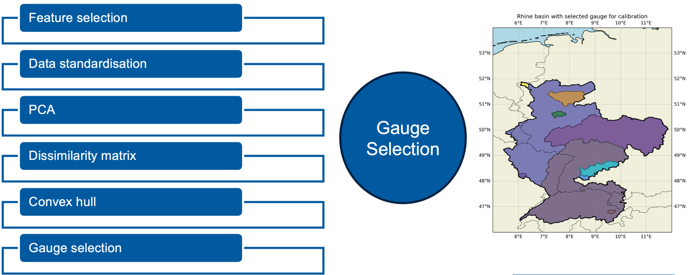
Additionally, a novel gauge selection algorithm has also been applied to optimize the multi-basin calibration process (illustrated in the attached figure).
At present, almost all modellers have completed their simulations for Experiments 10 and 2. The results from these experiments will be analyzed and discussed in the coming weeks.
📈 Experiment 3
The third experiment focuses on assimilating high-resolution EO data produced during the Round Robin phase into the models. It is currently in progress, and the results are expected to be reflected in the designed science cases in the WP6.
The discharge simulation using mHM model at high spatial resolution (0.015625 degree)
Revision Date: May 5, 2025
The paper based on Experiment 2 is close to completion, while the paper derived from Experiment 3 is currently in preparation.
Science Cases (Status: In progress):
Revision date: September 28, 2024
The kick-off meeting for various Science Cases takes place in September and October.
Below is a list of the various science cases.
SC1 – Forecasting extreme streamflow
SC2 – Simulating soil-moisture droughts
SC3 – Assessing water resources and hydropower potential
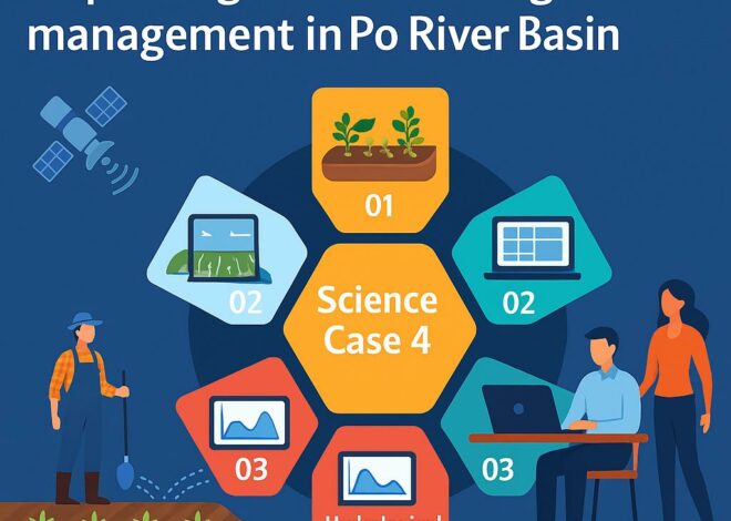
SC4 – Improving water and irrigation management
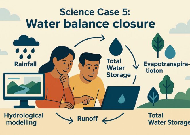
SC5 – Water balance closure
Revision Date: May 5, 2025
Each science case has completed its activities, and the corresponding reports are currently under review. Once the reviews are finalized, a summary of each science case will be published on the website. Additionally, the results of the science cases, though possibly not all, will be submitted for publication as scientific papers.
Community Building and Outreach (Status: Not started):